High-resolution climate projections for the
Edmonton Metropolitan Region

See how the modelling team at PARC provided detailed climate projections to help the city of Edmonton prepare for climate change.

Providing scientific support

The City of Edmonton marked a heightened commitment to climate action through participation in the Intergovernmental Panel on Climate Change (IPCC) Cities and Climate Change Conference in March, 2018. The Edmonton Declaration – a worldwide call to action on cities to take targeted, accelerated and ambitious climate action – arose from the conference. PARC was identified to help provide Edmonton with the climate projections needed to assess its approach to climate adaptation.

Climate projections have been developed over central Alberta from Global Climate Models (GCMs) over large geographic areas before; however, they are not relevant to city planners, engineers, and other practitioners due to limitations in their detail at the municipal level. We address this by providing climate change projections at relevant scales of space and time to the City of Edmonton through Regional Climate Models (RCMs). Various scientific papers and reports (e.g., AOS Foundation, 2018; Jiang et al., 2017; Kienzle et al., 2012) describe change in the climate and hydrology of central Alberta. In every case, the climate change projections used were based on GCMs with a large degree of uncertainty. Figure 1 illustrates the level of detail gained / lost when comparing GCM and RCM outputs.

The North Saskatchewan River Basin

The NSRB has a drainage area of 28,100 km2 and elevations ranging between 611 (Edmonton) and 3,543 m (Rocky Mountains) above sea level (Figure 1), and a variety of land cover uses (Figure 2). Average annual precipitation across the drainage area is 619.5 mm (1979-2016), but varies from 475 mm at Edmonton to more than 1,000 mm in the Rocky Mountain ranges. The average 1979-2016 minimum and maximum temperatures over this region are -12.3o C and 13.6o C, respectively, but also varies significantly between the mountains and the plains.

Designated a Canadian Heritage River, the mean annual discharge of the North Saskatchewan River (NSR) at Edmonton is 215 m3/sec. The origin of the NSR is the Saskatchewan Glacier in the Columbia Icefields. The glaciers of the Columbia Icefield experienced dramatic changes from 1919 to 2009, losing 22.5% of their total area while retreating more than 1.1 km on average (Tennant and Menounos, 2013).

Fig1_EMR
Figure 1. Model projections of the near future (2021 - 2050) average annual temperature in the EMR at four different spatial resolutions: > 110, 30, 10 and 3.3 km. Adapted from Sauchyn et al. (2021).

Thus, this project fills a knowledge gap in terms of the scale and type of information required to implement adaptation plans for Canadian cities, with Edmonton as the case study. Summarized within this case study, you will find the type of scientific support that is required for our partners at the City of Edmonton to implement their ambitious climate change adaptation and resilience strategy.

The Edmonton Metropolitan Region

Home to approximately 1.3 million and covering over 9,000 km2 (Statistics Canada, 2016), including the North Saskatchewan River valley, the Edmonton Metropolitan Region (EMR) exhibits a wide range of natural and socio-economic diversity. As such, the effects of climate change and extreme events are likely to be different and experienced differently among neighbourhoods. Historically, we have seen that community members who are less resilient (i.e., have less capacity to prepare for disruptions, recover from stress and adapt to changes) due to their socio-economic status will be disproportionately affected by large-scale extreme events and the progressive impacts of climate change (Rayner and Malone, 2001).

The EMR has seen a progressive increase in average annual temperature (Figure 2) from historical weather station data, with an increase of approximately 2 °C from 1884 to present. The take home message from Figure 2, however, is that Edmonton is not getting warmer per se; rather, it is getting less cold with winter temperatures (December, January, February) warming by over 6° C over a similar period (Figure 3). This phenomenon is common in much of Canada and other seasonally-cold regions where snow cover continues to decrease (IPCC, 2021), resulting in less sunlight being reflected back into the atmosphere. 

Figure 2. Average annual temperature at Edmonton (degrees C) from 1884 - 2020 with a linear trendline. Adapted from Sauchyn et al. (2021).
Figure 3. Average daily winter (December, January, February) temperature at Edmonton (degrees C) from 1880 - 2020 with a linear trendline. Adapted from Sauchyn et al. (2021).

Modelling climate: past and future

Climate projections for Edmonton were generated from the National Center for Atmospheric Research (NCAR) Weather Research and Forecasting (WRF) Model 4.0 (Shamrock et al., 2019) at a spatial resolution (i.e., the pixel size of the model) of 3.3 km, as well as 10 and 30 km. A number of climate variables (temperature, precipitation, humidity, etc.) were generated every six hours. These were simulated for 30-years periods of 1976 – 2005, 2021 – 2050 and 2051 – 2080, assuming an RCP 8.5 scenario – which, in other words – assumes very high greenhouse gas (GHG) emissions in the future. See the end of the case study for more information on RCP scenarios.

In addition to applying RCMs, a reconstruction of the past climate (paleoclimatology) from tree-ring data (see PARC’s Tree-Ring Lab) of the North Saskatchewan River Basin (NSRB) from Sauchyn et al. (2020) was used to understand the natural variability of the region through a larger dataset of climate (1888 – 2100). This record captures a large range of natural variability in Alberta’s hydroclimate and is thus noted as a significant source of model uncertainty where departures from the climate change trend are observed.

A snapshot into Edmonton's future climate

Average annual precipitation and temperature are expected to increase from the period 2021 – 2080, following the high-resolution (3.3 x 3.3 km) model projections for Edmonton. Figure 4 and 5 depict this upward trend, with Figure 5 demonstrating a large range of variability in annual precipitation from year to year.

Figure 4. Time series of average annual temperature (degrees C) with a linear trendline at Edmonton, AB, for 2021 - 2080. Adapted from Sauchyn et al. (2021).
Figure 5. Time series of average annual precipitation (mm) with a linear trendline at Edmonton, AB, for 2021 - 2080. Adapted from Sauchyn et al. (2021).

Following the record-setting heat waves felt across western Canada, significant attention has been given to daily maximum temperatures. Although Edmonton did not set a record daily high temperature in the summer of 2021, the City did set a record for the most consecutive days with a daily maximum temperature exceeding 30° C at seven days (June 26 – July 2). Figure 6 shows the projected increase in average annual average daily summer maximum temperature for the City, which is expected to increase 3.6° C from 2021 – 2080 (Sauchyn et al., 2021).

Figure 6. Time series of average daily summer (June, July, August) maximum temperature (degrees C) with a linear trendline at Edmonton, AB, for 2021 - 2080. Adapted from Sauchyn et al. (2021).

Managing uncertainty

This project provides the City of Edmonton with a unique database of climate projections at a scale relevant for planning and decision-making. We controlled for uncertainty due to human-caused climate change by using a single GHG emission scenario (RCP 8.5) throughout our modeling and analysis. RCP 8.5 is a high emission scenario and is commonly used because global GHG emissions continue to escalate and have yet to level off.

Natural climatic variability is the dominant source of uncertainty in the prediction of the future climate of western Canada. It accounts for about 90% of the total variance among climate model projections of future precipitation over the next few decades (Barrow and Sauchyn, 2019). We address this variability through the use of a paleoclimate record (Sauchyn et al., 2020), which has the advantage of greater record length that pre-dates substantive human interference with the global climate system.

By explicitly exploring the full range of uncertainty, and understanding the sources, we can make recommendations for accommodating uncertainty in decision making, including the extent to which existing risk and asset management strategies designed for historical weather events will require adaptation to a shift in hydroclimate variability and frequency / magnitude of extreme events.

For further reading

Acknoledgements

Funding for this research was provided by an IPCC Cities Legacies grant administered by Alberta EcoTrust and a Natural Sciences and Engineering Research Council of Canada grant from the Collaborative Research and Development program.

We thank the assistance of Simon Irving (Alberta EcoTrust), Danielle Koleyak (City Environmental Strategies), and EPCOR Water Canada.

Citing this case study

Sauchyn, D.J., S. Basu, M.A. Anis, Y. Andreichuk and S. Kerr (2021). High-resolution climate projections for the Edmonton Metropolitan Region. Prairie Adaptation Research Collaborative. https://data.parc.ca/emr [Insert your data of access here.]

References

All One Sky (AOS) Foundation. 2018. Edmonton metropolitan region climate resilience exchange: State of knowledge summary. October 30, 2018.

Barrow, E.B. and D.J. Sauchyn. 2019. Uncertainty in climate projections and time of emergence of climate signals in western Canada. The International Journal of Climatology. doi:10.1002/joc.6079.

IPCC, 2021: Climate Change 2021: The Physical Science Basis. Contribution of Working Group I to the Sixth Assessment Report of the Intergovernmental Panel on Climate Change [Masson-Delmotte, V., P. Zhai, A. Pirani, S. L. Connors, C. Péan, S. Berger, N. Caud, Y. Chen, L. Goldfarb, M. I. Gomis, M. Huang, K. Leitzell, E. Lonnoy, J. B. R. Matthews, T. K. Maycock, T. Waterfield, O. Yelekçi, R. Yu and B. Zhou (eds.)]. Cambridge University Press.

Jiang, R., T.Y. Gan, J. Xie, N. Wang and C.C. Kuo. 2017. Historical and potential changes of precipitation and temperature of Alberta subjected to climate change impact: 1900-2100. Theoretical and Applied Climatology, 127(3-4): 725-739.

Kienzle, S.W., M.W. Nemeth, J.M. Byrne and R.J. MacDonald. 2012. Simulating the hydrological impacts of climate change in the upper North Saskatchewan River Basin. Journal of Hydrology, 412-413: 76-89.

Rayner, S. and E.L. Malone. 2001. Climate change, poverty, and intragenerational equity: The national leve. International Journal of Global Environmental Issues, 1(2): 175-202. doi:10.1504/IJGENVI.2001.000977.

Sauchyn, D.J., M.R. Anis, S. Basu and Y. Andreichuk. 2020. Natural and Externally Forced Hydroclimatic Variability in the North Saskatchewan River Basin: Support for EPCOR’s Climate Change Strategy. Final report to EPCOR.

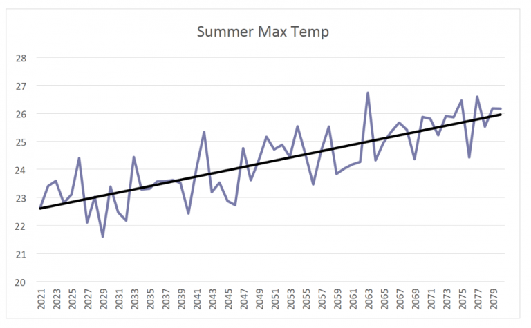
Sauchyn, D.J., S. Basu, M.R. Anis, Y. Andreichuk and S. Kerr. 2021. High-resolution Climate Change Projections for the City of Edmonton. Final report to Alberta EcoTrust and the City of Edmonton.

Skamarock, W.C., J.B. Klemp, J. Dudhia, D.O. Gill, Z. Liu, J. Berner, W. Wang, J.G. Powers, M.G. Duda, D.M. Barker and X-Y. Huang. 2019. A Description of the Advanced Research WRF Version 4. NCAR Technical Note. NCAR/TN-556+STR, 145 pp. doi:10.5065/1dfh-6p97.

Statistics Canada. 2017. Edmonton, 2016, Alberta. Census Profile. 2016 Census. Statistics Canada Catalogue no. 98-316-X2016001. Ottawa. Released November 29, 2017.
https://www12.statcan.gc.ca/census-recensement/2016/dp-pd/prof/index.cfm?Lang=E (accessed September 1, 2021).