Paleohydrology of the Athabasca River Basin

In this case study, we reveal how tree ring data dating back 900 years were used to provide water management guidance to Alberta’s oil and gas industry, and expand our understanding of past droughts in the Athabasca River Basin. 

Looking back to plan ahead

The presence of the world’s third-largest crude oil sands reserve in Alberta has placed high demand on the province’s fresh water resources, which are required partly for the extraction and processing of bitumen. Despite a recent decline, Alberta’s energy sector still contributes the highest gross domestic product in the country as of 2019 (Statistics Canada, 2020). The Athabasca River is the primary source of water for the Alberta fossil fuel industry, with 74.5% of total surface water allocations attributed to the industry (Sauchyn et al., 2015). This allocation has increased steadily in recent decades (Figure 1); however, it is based on a short-term record of stream gauge data that does not account for long-term variability and changes in climate. Ideally, water allocations should take into consideration long-term variability to examine reliability, and in the context of increasing human activity and future climatic change. Or as Dave Sauchyn, Director of PARC and lead researcher of this project, asks in context: “how reliable is the Athabasca River Basin as a source of water given the major expansion of oil sands production that has occurred and is planned?” (Maragos, 2015).

Figure 1. Water allocation in billions of cubic metres by sector for the Athabasca River Basin, 1960-2010. Adapted from Sauchyn et al. (2015), with permission from the Government of Alberta.

To answer this question, Sauchyn et al. (2015) set out two objectives with which to examine long-term (decades) variability in discharge (flow) in the Athabasca River Basin (ARB), which we will review:

1) assess the trends and uncertainty in gauge records of flows; and

2) produce a 900-year reconstruction of annual and seasonal flow of the Athabasca River using tree-ring substitutions of flow.

The Athabasca River Basin

The Athabasca River Basin (ARB), depicted in Figure 2, covers 24% of Alberta’s landmass and is the second-largest river in the province. Fed by snow melt from the Columbia Glacier, the ARB provides ecologically important wetland habitat, and its intersection with the Peace river at Lake Athabasca forms a UNESCO World Heritage Site (Athabasca River Basin Research Institute, 2017).

Figure 2. Major drainage basins of Alberta. Adapted from Sauchyn et al. (2015), with permission from the Government of Alberta.

Using trees to assess the past

Stream flow records from stream gauges fail to capture the full range of variability (highs and lows) that can be detected by a longer proxy record. A proxy is a physical feature(s) of an environment that has been preserved (e.g., tree-ring, ice core) and can be used as a substitute for measurements. Moreover, gauges are prone to data gaps due to instrument error and malfunction, decommission, and loss during flood events. Nine periods of stream flow of at least 55 years in length were obtained from gauges during the period 1913 – 2013. The influence of multi-year climate variability (teleconnections), which can exert impacts on flows in the Canadian Prairies (St. Jacques et al., 2014), was removed to isolate flow changes related to regional climate. Declining flows in the ARB were evident in the relatively short instrumental record.

River flow was reproduced and reconstructed from tree rings of long-standing trees at a network of sites in the upper reaches of the ARB and in nearby watersheds by the PARC and the University of Regina Tree-Ring Lab. Dating and understanding past events from tree rings is known as dendrochronology. Long-term flow reconstructions indicate that river flow has been more variable than short-term gauge records indicate. This is not surprising that a longer record of data yields more insight into the nature of the river and its behaviour. This does, however, hold tremendous implications for the oil sands industry and water management at a broader scale in light of a warming climate that is likely to produce persistent drought events (Sauchyn et al., 2020).

Applying the data to water management

Many studies have examined stream flow trends in the Canadian Prairies, particularly as growing concerns of a changing climate, water allocation and management, and environmental stewardship within the context of economic growth continue to shape the landscape. This study was novel in that it removed the influence of large-scale variability caused by teleconnections.

Five tree-ring reconstruction models were used to reproduce stream flow, all of which demonstrated statistical significance (i.e., didn’t work simply by chance) in predicting as compared to gauged flow for the period 1962-2017 (Figure 3). This indicates the reliability of the tree-ring models in not only reconstructing flow before we could directly measure it, but speaks to the ability of the models to reproduce accurate results when compared with direct measurements.

Figure 3. 1962 - 2017 comparison of instrumental (blue) and reconstructed (black) water-year (October - September) flow (in cubic metres per second) of the Athabasca River. Adapted from Sauchyn et al. (2015).

The 900-year reconstruction of flow (Figure 4) uncovers periods of severe drought (e.g., 1790 – 1806) and prolonged drought (1311 – 1409) that are otherwise not represented or known due to the relatively recent record of monitoring stream flow through gauges. As such, water allocation and management must take into consideration longer-term trends and observations of flow to incorporate the larger range of variability. This is particularly salient as the climate continues to warm and sustained droughts are expected to impact the Canadian Prairies.

Figure 4. AD 1111 -2018 reconstruction of water-year (October - September) flow (in cubic metres per second) of the Athabasca River from tree-ring reconstruction. Adapted from Sauchyn et al. (2015).

As water management decisions have largely been framed on relatively short and incomplete instrumental records of stream flow and discharge, there is a lack of data and sound understanding of the longer-term variability and potential for low- and high-flow events that can impact sustainability and feasibility at a number of scales. With the Canadian Prairies expected to experience warmer temperatures and a decrease in average summer precipitation (Sauchyn et al., 2020), we can expect more low flows within the ARB and beyond.

For further reading

Acknoledgements

This project was sponsored by Canada’s Oil Sands Innovation Alliance, and provided the oil sands industry with an expanded perspective on the variability and reliability of their major surface water supply; a perspective that captures extremes of climate and water levels that are outside the range of recorded historical flows.

Funding was provided by the Natural Sciences and Engineering Research Council of Canada, the Canadian Oil Sands Innovation Alliance and the Meteorological Service of Canada. Thanks are extended to field and lab assistants James Dickenson, Jana Hozova and Jakub Hacura.

Citing this case study

Sauchyn, D.J., J-M. St. Jacques and D.H. Luckman (2022). Paleohydrology of the Athabasca River Basin. Prairie Adaptation Research Collaborative with adaptation from Sauchyn et al. (2015). https://data.parc.ca/arb [insert your date of access].

References

Maragos, C. (2015). Research reveals water source concerns for oil sands development. University of Regina, 22 September 2015. https://www.uregina.ca/external/communications/feature-stories/current/2015/fs-09222015.html Accessed: 26 January 2021. 

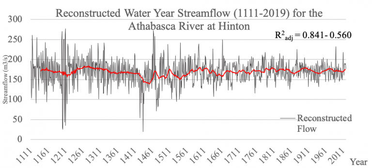
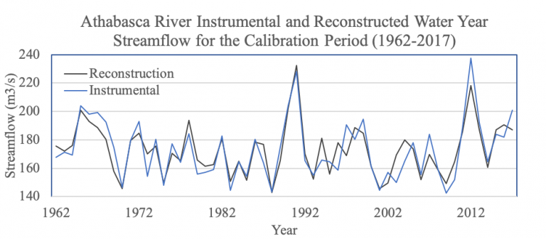
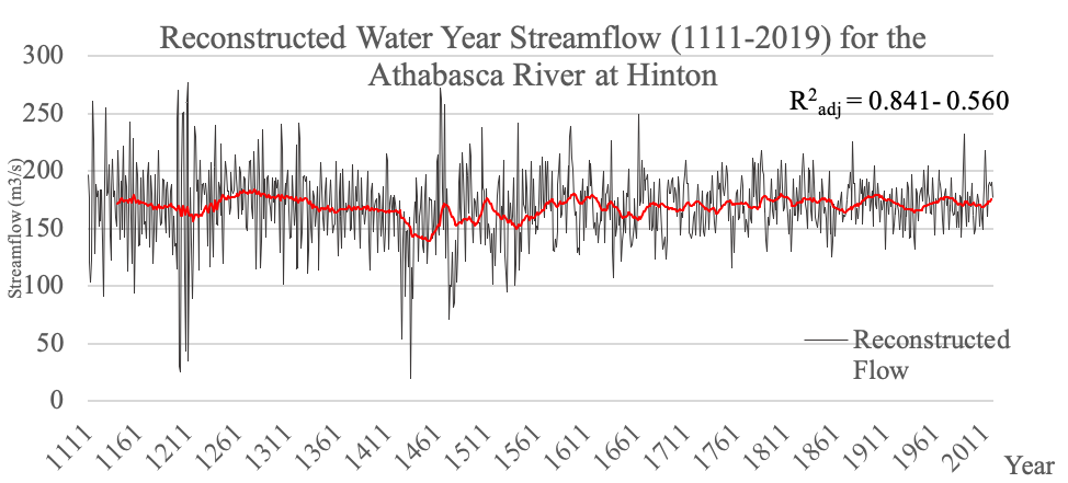
Sauchyn, D.J., J-M. St-Jacques, and B.H. Luckman (2015). Long-term reliability of the Athabasca River (Alberta, Canada) as the water source for oil sands mining. Proceedings of the National Academy of Sciences, 112(41): 12621-12626.

Sauchyn, D.J., D. Davidson, and M. Johnston (2020). Prairie Provinces; Chapter 4 in Canada in a Changing Climate: Regional Perspectives Report, (ed.) F.J. Warren, N. Lulham and D.S. Lemmen; Government of Canada, Ottawa, Ontario.

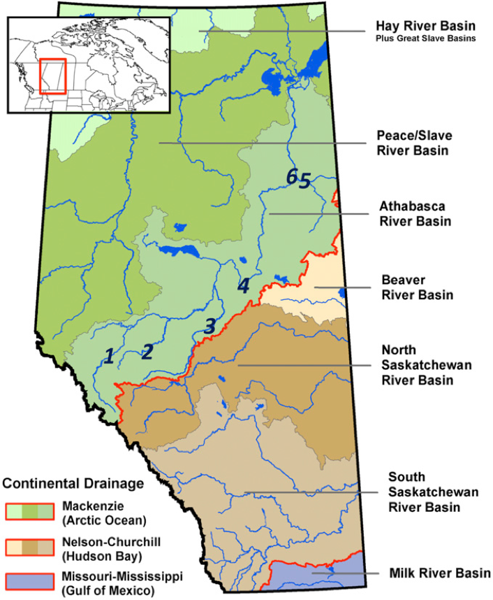
Sellers, J. (2017). About the Athabasca River Basin. Athabasca Basin Research Institute, 2017 September 13. http://arbri.athabascau.ca/About-the-Athabasca-River-basin/Index.php Accessed: 13 April 2021.

St-Jacques, J-M., Y.A. Huang, Y. Zhao, S.L. Lapp, and D.J. Sauchyn (2014). Detection and attribution of variability and trends in streamflow records from the Canadian Prairie Provinces. Canadian Water Resources Journal, 39(3): 270-284.

Statistics Canada, 2020. Gross domestic product (GDP) at basic prices, by industry, provinces and territories, percentage share. Statistics Catalogue no. 36-10-0400-01. Ottawa. Version updated 2020. https://doi.org/10.25318/3610040001-eng Accessed: 26 January 2021.